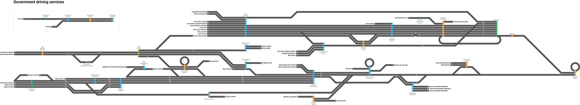
Recently, a team of people from DVLA, DVSA, and GDS created a map of how driving services work. The map brings together knowledge from across government, into one agreed version of driving services. It's really helped communicate and encourage discussion about the opportunities for using patterns, platforms and registers for designing driving services. (You can download a full-size version of the driving services map on our Flickr page.)
Following the great work on mapping the justice system, lots of people have asked for similar maps of their service areas, for example one to show all the services involved in importing and exporting goods. At first we weren’t sure about mapping driving services but we soon realised there was stuff we needed to explain, and a graphic would be more useful than numbers or words to depict:
- the similarity between the different services
- how a transaction can be a part of several different services
- how a service can be provided by more than one part of government
What we mapped
It’s worth reminding ourselves how we define a service - ‘a service is a set of transactions and activities that share a user need, arranged in a way that helps a user to do something, on or offscreen. ‘
First we mapped 42 driving services, from a user’s perspective. These included 'learn to drive', 'import a vehicle', 'drive a taxi', 'employ a driver' and 'buy a vehicle'.
Then we mapped the transactions that make up each of the 42 driving services. So for example, a user learning to drive will need to:
- apply for a provisional licence
- book a theory test
- find a driving instructor
- book a driving test
- take a driving test
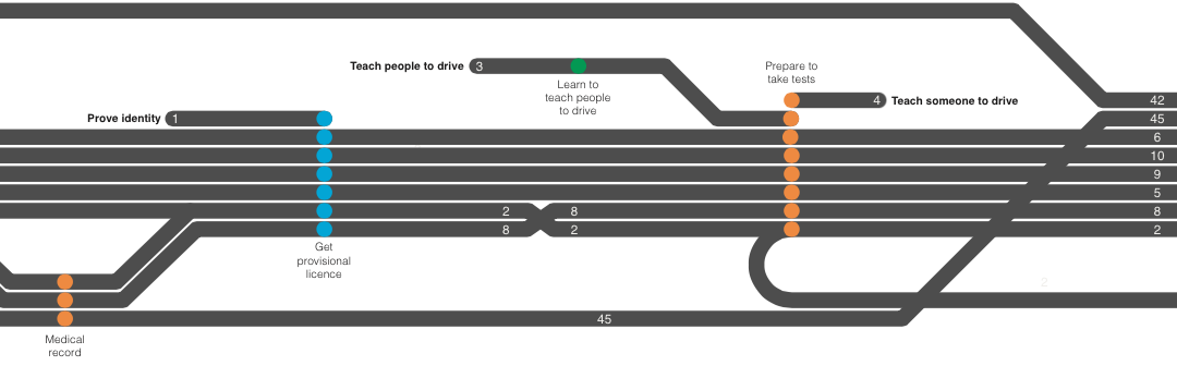
We also mapped which department or agency was responsible for each transaction.
Each service has a starting point with a name and number. These numbers reference a spreadsheet of all the GOV.UK guidance and transactions that make up services. This means that when people working on part of a service ask, "where’s my bit?", we can say, "there, it’s number 29."
How we made the map
The map itself took about 5 days to produce, but it's grounded in years of knowledge collectively held by the people who work on driving services.
This is the first time a user's perspective of the service, and this long held internal knowledge have been shown in one place in this way. We spent time with colleagues in service teams in Bristol and Swansea, and in garages, test centres and on the hard shoulder of motorways. What really took time was not drawing the map, but understanding what to draw.
We worked with DVLA and DVSA services managers, John Hewson and Ingrid Morris, and user researcher Clare Barnett, to organise the transaction and service information into a single graphic. We thought long and hard about how we could arrange the information as clearly as possible; we had to choose the most suitable format. We’d been inspired by a bus map, which suited the information well as it showed the intersection between firmly held points in the same way - the information decided the format.
What we learned
When buying a vehicle a user may go through several transactions, eg:
- checking a vehicle's history
- changing the vehicle's keeper
- paying road tax
- transferring a personalised registration
- getting a parking permit
- insuring a vehicle
There are dependencies between these transactions, and there’s a user and a government need for transactions to be modular by design. The map has made this easier to understand.
The mapping exercise also taught us that:
- a service doesn’t always include the same transactions, eg a user importing a vehicle may or may not need to get it tested (MOT’ed) before registering it
- a record on a register for a service can have entries from multiple users, eg someone with an HGV operators licence has to keep a record of the vehicle’s maintenance, the number of driving hours, and company finances; mechanics, drivers and accountants must all update the same HGV record separately with different information
- a register is often used in more than one transaction, eg the driving licence register is used in transactions to check, share and update licence details, and to check a private record
Having a map of how the service currently works, helps to inform how that service should be designed. It can tell us which services we should work on, how to work on those services and who with. The map also identifies where patterns and standards can be used in driving services.
It was tempting to map everything and include services, transactions, who does what, policy, technology, contracts, projects and upcoming legislation. To keep our map as clear as possible we only included the first three. As Stephen McCarthy says in the GDS design training, "It says so much, it says nothing."
A map is just a start. It won't meet user needs - services will do that. Yet a map, along with other things, can help inform the design of services.
You can email harry.trimble@digital.cabinet-office.gov.uk if you would like to receive a PDF of the government driving services map, or if you'd like to discuss it.
Follow Harry on Twitter and don't forget to sign up for email alerts.
If this sounds like the kind of thing you'd like to work on, we're currently hiring for developers and web operations engineers. Or drop us a line at gds-recruitment@digital.cabinet-office.gov.uk
2 comments
Comment by Joe posted on
It would be good if you at least provided up to date links - I clicked on the link to email Harry and got Sorry, but the page you were trying to view does not exist.
It looks like this was the result of either:
##a mistyped address
##an out-of-date link.
The reason I was trying to get in touch was to ask why the map was download was on Flickr. I am sure I am not alone in that most company IT systems will not allow access to social media or file sharing platforms for security reasons. A little prior research on what was needed by the business sector would have been helpful.
Comment by Nettie Williams posted on
Hi Jo - thanks for pointing out the email issue. Now fixed. And Harry's emailed you separately about the PDF.